CompassCom
GPS Tracking Solutions
![]()
Engine Diagnostics, Third Party Integration, Snow Solutions
Radio Tracking Solutions
![]()
On and Off the Grid:
- Motorola P25
- MotoTRBO
Plug and Play Output Connectors
Esri, Cityworks, TAK, NG911, Rapid Deploy, CAD, and other ASM/WOMS third-party Systems
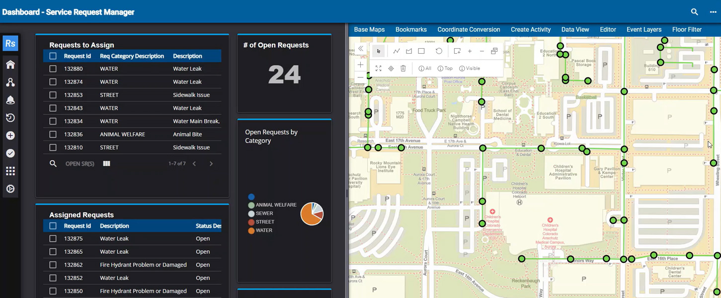
Effective management and safety starts with knowing the location of your people and assets.
Real-time GPS telematics solutions
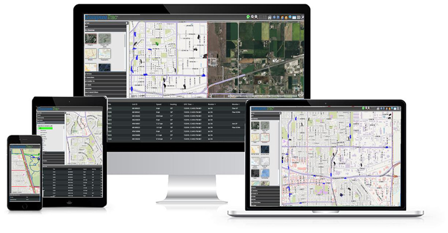
Users experience enhanced command and control via desktop, laptop, tablet, and smartphone viewing real-time asset location with a common operational picture leveraging the power of Esri ArcGIS. Replay, dashboards, and on-the-fly analytics supports operational excellence using location intelligence to empower results you can trust.
TOP 5 REASONS TO USE CompassCom
Real-time Telematics That Works for You

Interoperability of Motorola Radio and Broadband Cellular Wireless
- Real-time tracking of broadband cellular devices, Motorola ASTRO P25, and MOTOTRBO mobile radios simultaneously on one platform.
- Eliminate multiple tracking solutions for your organization with one Telematics solution to support multiple department workflows.
- Secure Cloud or on-premises deployments with IA certified for National Security, First Responder and critical infrastructure missions.

Esri Based Viewer & Map Services Configurable to Your Workflow
- CompassCom’s platform is integrated with Esri ArcGIS
- Common operational picture to integrate real-time data into your organization's GIS map
- An Esri Partner since 1994 we deliver or configure ArcGIS to meet your mission requirements.
- Our off the shelf solution enables Esri users to deploy ArcGIS solutions quickly and cost effectively without long and expensive integrations efforts.

Real-time Display
- View mobile asset performance in real-time in the office or in the field via desktop, laptop, tablet, and smartphones.
- Breadcrumb display of activity with full metadata, routing, geofencing and alerts for full operational control.
- Esri ArcGIS integration to support ArcGIS Online and the customers GIS infrastructure in a Common Operational Picture.

Historical Replay & Reporting
- On-the-fly reporting by single asset, groups of assets or an entire fleet.
- Ability to set your reporting cadence to align with and support operational requirements.
- Historical replay for after action review and analysis to support enhanced customer service and accountability.

CityWorks, Esri and 3rd Party Output Connectors
- "Plug and Play" capability through output connectors to Esri, Cityworks, 3rd party CAD, asset management and work order management systems.
- Easy integration with CompassCom API to supporting custom workflow requirements.
- Interoperable platform and apps that support cost effective and quick integration.
Deployment Solutions
CompassCom deploys it’s system as a SAAS, On-Premise, or portable solution while maintaining the highest level of security.
![]()
CompassWorks® is a Software as a Service (SaaS) fleet tracking and management solution that leverages the power of Esri ArcGIS (SOC-2 compliant -MS Azure)
![]()
CompassTrac Enterprise On-premise Motorola P25 conventional, P25 trunking, MOTOTRBO DMR, fleet tracking and management solution to support deployments where ownership, control, and security is the requirement (IA Compliant)
![]()
CompassRespond™ For when the mission is "off the grid" and real-time situational awareness and safety are paramount, this portable system empowers tactical response.
Output Connectors
Connect with your 3rd party software with standard output Connectors.
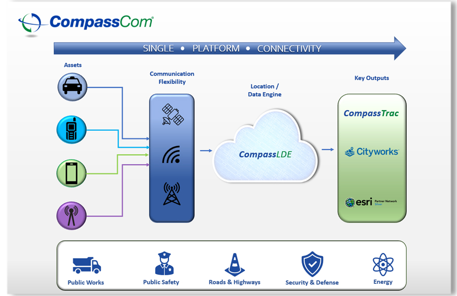
Connect applications, services, and data through standard published API and database for a plug and play experience. Standard and proven interfaces for:
- Esri ArcGIS, Geo Event, Velocity
- Cityworks Desktop and Respond
- Computer Aided Dispatch
- NG 911
- ERP systems
Increase Efficiencies & Enhance Your Operations
Download our Brochure
CompassCom is a long and loyal partner of Esri and is our most successful Esri Partner leveraging ArcGIS in the telematics business"
Terry Bills
Transportation Industry Director - Esri
Maximizing Efficiency and Accountability: The Crucial Role of Street Sweepers in Public Works
Press Release: CompassCom Releases Upgraded Telematics Platform with Enhanced Situational Awareness for Asset Tracking and Fleet Management
Cityworks Partner Summit – CompassCom in attendance
CompassCom User Summit
Subscribe to stay up-to-date...